The Ring of Fire
On board the Mermaid Sapphire near Rabaul, Papua New Guinea
“This is not the Ring of Fire of television and books; this is the real thing.”
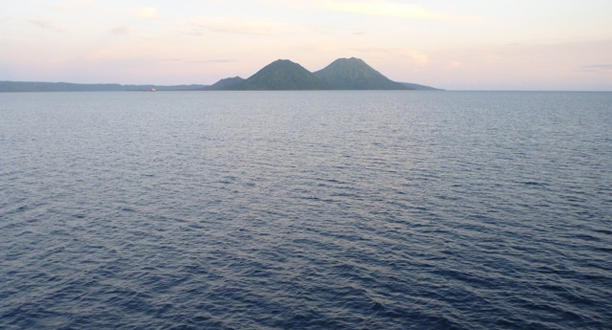
That’s what one of the crew members says as we head toward the entrance to Blanche Bay on New Britain Island. Ten of us are leaning against the bridge deck railing taking pictures of three purple volcanoes dominating the skyline ahead of the ship. As we draw closer, their stark triangular shapes catch the first rays of the sun and shift slowly from purple to green. The volcanoes are on the Crater Peninsula just east of Rabaul. The two biggest, Kombiu and Taranguna, rise more than 1,500 feet (457 meters). Tavurvur, the smallest, is half their height.
“After seven days at sea, this is an amazing sight,” says Ben Orchard, a sub team electronics specialist. “The kind of landfall you imagine when you’re a kid.”
The Ring of Fire is a belt of intense earthquake and volcanic activity around the outer limits of the Pacific Ocean. It’s 30,000 miles (48,280 kilometers) long and runs up the west coast of South and North America, along the Aleutian Islands, and down through Japan, the Philippines, and Indonesia. The “ring” contains most of the active volcanoes on Earth. From Chile to Alaska to Japan, earthquakes along its boundaries have killed hundreds of thousands of people.
As we approach the peninsula, we see puffs of white smoke coming out of Tavurvur’s caldera. At our nearest point, we can see into her enormous crater surrounded by a steep volcanic ridge. On September 19, 1994, Tavurvur exploded and sent thick columns of ash thousands of feet into the air. The people living in Rabaul had 19 hours warning. Lightning from the eruption killed five inhabitants. The ash fall was so thick that it destroyed the airport and collapsed most of the town’s buildings. We gaze on the huge field of gray ash sloping down to the shoreline and try to imagine what it must have been like for the people who were there the day the sky blew up.
An hour after we moor up against the big concrete pier in Rabaul, Jim Cameron, Maria Wilhelm, Ron Allum, Dr. Glenn Singleman, John Garvin, Tim Bulman, Peter Batson, Doug Bartlett, Erika Montague, and other members of the team arrive and begin loading personal gear and a ton and a half of camera equipment onto the ship. The sub team pitches in. Container doors are opened and black Pelican cases pushed inside. The Spirit of Niugini (New Guinea), a 50-foot (15-meter) live-aboard dive boat, ties off to the port side of the Mermaid Sapphire. For the next seven days, she’ll be home and kitchen for 12 members of our team.
At mid-afternoon, the ship eases away from the pier and heads to Jacquinot Bay, 130 miles (209 kilometers) to the west. On the way out of the harbor, Jim describes yesterday’s helicopter flight over the bay’s clear blue waters. “We saw a pod of 40 dolphins swimming around the rim of the bay,” he tells me. “The local people told me they make this feeding circle almost every day.” We go up the bridge deck for a better look at Tavurvur’s elliptical caldera. “Yesterday I talked to some of the people living nearby,” Jim says. “Their houses are built on the ash fall. It’s like a nuclear wasteland.”
For the next hour, as the Mermaid Sapphire heads into the open ocean, Jim and I talk about his upcoming dives into the New Britain Trench. We discuss the Ring of Fire—how heavy tectonic plates grind across the Pacific for millions of years until driven beneath lighter plates and how these enormous forces hidden deep beneath the sea create volcanic eruptions. “If I’m lucky on my dive into the New Britain Trench, I may get a close-up view of a subducting plate,” Jim says, smiling. “If I’m unlucky, I’ll get bounced by an earthquake.”
Photograph by Joe MacInnis