Master Navigator
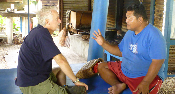
“We do it for the betterment of our people. We do it for safety.” Ali Haleyalut looked at Jim and smiled. Jim nodded slowly. “I understand.”
The two men were sitting under a thatched-roof house on the island of Falalop in Ulithi, an atoll in the westernmost Caroline Islands. Ali, 55, is one of those rare individuals known as a master navigator, someone with the skill and experience to sail an outrigger canoe thousands of miles across the open ocean without benefit of a compass, using information gleaned only from the sky and the sea. During the night he reads the patterns of stars as they move across the heavens; during the day he reads the composition of waves as his long-keeled boat slips between them. From the Southern Cross to the North Star, he knows the names of more than 160 stars and where they rise and set on the horizon. He knows how to read the direction, size, and speed of ocean waves and how they reflect off unseen islands. Cloud formation, land-based birds, and shallow water reflections on the undersides of clouds help guide him to his target island.
“It takes years of memorizing and calculations to become a master,” he told Jim. The man who had recently dived his new research sub to 26,000 feet (7,925 meters) smiled, “You have an incredible skill.”
They talked for more than an hour about how Micronesian outrigger canoes are made and the critical role of the master carver. Ali told Jim how food and water are carried in the canoes and how they troll for fish and cook them on a bed of stones. A rooster crowed in a nearby yard and children played under a breadfruit tree. They spoke about the eight levels of becoming a master and the importance of personal leadership. They discussed how the ocean informs you when a cyclone is coming. “One of the great lessons the sea teaches us,” said Ali, “is patience. When the wind dies and your boat stops, you still know where the island is, so you must be patient.”
Jim steered the conversation toward technologies like satellite navigation and GPS systems, and both men came to the same conclusion. These technologies are astonishingly helpful but you need to know what to do when they stop working; you need to know the basics.
The subject turned to global warming, rising sea levels, and threats to low-lying islands like Ulithi and thousands of others in Micronesia. “My father told me that it was essential to become a master navigator because we might have to go to another island. The old threats included famine; now there’s a new threat.”
They talked about a special ceremony that takes place before master navigators begin a long and perilous voyage. “The last time we had this ceremony,” said Ali, “was in 1975 when my uncle sailed to Okinawa. But you’re going on a very difficult voyage. I would like you and your co-pilot, Ron Allum, to join me tomorrow for a special blessing.”
The master navigator of the sea’s surface and the bold explorer of the sea’s depths clasped hands, and Jim smiled. “Thank you. We’ll take any blessing we can.”
Photograph by Joe MacInnis